|
|
 |
|
|
|
August 5 Baie Fine to Little Current
26.8 miles
|
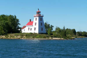
| Strawberry Island Light |
Along the way from Baie Fine to Little Current, we passed the very photogenic historic Strawberry Island
Light, erected in 1881.
One of its early lightkeepers was William McKenzie, who served there from 1883 until 1919. He
and his family crossed from the mainland to Strawberry Island by sleigh in March before the spring melt, and they left in
October, before the lake froze solid. His seven children only attended school in Little Current during the winter when
they weren't on the island.
For the past twenty years, Terry and Kay Gaffney have been summer residents/stewards of the light.
The lighthouse has no power, except for the solar panel that supplies the light itself, and the only running water is supplied
by a hand pump at the kitchen sink. The Gaffneys use lanterns fueled by kerosene or lamp oil for light in the evening.
We found Little Current to be poorly named. The name given to the area by the First Nations was more
accurate. They called it Wewebjiwang, "where the waters flow back and forth." The currents in this narrow section
of water are wind-driven, changing with the wind direction and speed. The area of most strong current is in the
narrowest part of the channel, which is, of course, the spot where the bridge spanning the channel was built. Its pilings
only add to the strength and treachery of the current.
When we passed through the bridge at its noon opening, a sailboat behind us lost power at the worst possible
time, and was driven into the bridge pilings. A trawler that went to assist was caught broadside by the current and driven
into pilings right next to the sailboat. We turned to assist, but were relieved that a boat from a local marina arrived to
provide assistance. Without local knowledge, getting too near the bridge pilings was clearly a dangerous proposition.
When we arrived in Little Current, we found Looopers who left Killarney for here at the same time we left
Killarney destined for Baie Fine. They have been trapped here by the wind for two more days than they planned to stay.
We strolled downtown and found it to be small, but a great provisioning stop, with everything we could want,
except a bakery. The marina even had wireless internet!
We joined ten other Loopers for dinner at the Anchor Bar and Grill, then grabbed ice cream at a stand on
the way back to the boat. Listening to the weather radio, we were optimistic that the winds would abate enough
the next morning so that all of us could cruise on.
August 6-7 Little Current to Benjamin Islands
23.8 miles
We left Little Current under sunny skies, with a temperature of 74 degrees, and fair winds. It was
yet another perfect cruising day in the north country.
It took us scarcely more than three hours to make our way to the Benjamin Islands. Though we didn't
understand all the geological happenings in the area of the Benjamins, we knew it was a place with a lot of different types
of activity, because of the very different appearance of the islands nearby. To our south was Clapperton Island, a long
flat island made of layered limestone. Next we passed Croker Island, a mound of red granite. Next to Croker was Secretary
Island, made of what looked like white quartzite uplifted in angled layers.
|
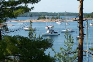
| Benjamins anchorage |
From an aerial view, the Benjamin Islands form a circle around a bull's-eye center. Geologically,
they are known as a pluton -- a dome of molten igneus rock which has risen to the surface and cooled. In the case of
the Benjamins, they rose 1450 million years ago, then eroded over time, so that now they are smooth warm red mounds of granite,
with a few intriguing instrusions of other rocks embedded in them.
There are lots of nooks and crannies between the islands to explore by dinghy or kayak, and the bigger
islands offer opportunities to climb about and search for blueberries.
We enjoyed the Benjamins so much we decided to stay two days. We hiked to the top of the tallest island,
picking blueberries all along the way. We explored around the Benjamins by dinghy, and took dinghy excursions to
nearby islands -- Fox Island, another popular anchorage area, and Hook Island, known for its many fossils. We picked
up a few fossil treasures, and marveled over many more too big and too plentiful to take away. The fossils bore evidence
that 450 million years ago this area was a shallow tropical sea.
We hopped off our swim platform to swim in the clear cool water.
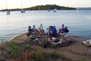
Since the ban on fires was raised two days ago, we joined Summertime and CORI for a
picnic on the rock shore, followed by a campfire with S'mores. Our fire was especially effective and efficient, because it
was made by Rick, a retired fireman. He perfectly predicted, to the minute, when his blazing inferno would fade to glowing
coals, perfect for marshmallow toasting.
For those who like a good ghost story around the campfire, the Benjamin Islands are named for an early lighthouse
keeper who disappeared mysteriously. Benjamin Baker was the keeper of the Clapperton Island light from 1875 until 1894,
when he never got home after carrousing with friends one night in Gore Bay. The next day his sailboat was found drifting with
his dog, his empty wallet and a whiskey bottle. The family saved the whiskey bottle for years, until one day his daughter-in-law
sneaked a nip from it, and became violently ill. Perhaps he was poisoned? No one knows.
August 8 Benjamin Islands to Kagawong (On Manitoulin Island)
18.1 miles
|
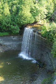
| Bridal Veil Falls |
Kagawong means "where the mists rise from the falling waters." The name refers to the spot now known
as Bridal Veil Falls, one of two must-see destinations for anyone stopping in Kagawong.
We hiked a 3/4 mile trail beside a stream and through the woods to reach the falls, where we stood beneath
the falling water and felt the drops hit us like little hail stones. Then we sat on a shelf behind the falls, where
it was about ten degrees cooler than the air we had been hiking through. After a little swim in the pool at the bottom
of the falls, we climbed the steps to the top, and walked back to town (such as it is) along the sparsely populated and lightly
traveled main road.
|
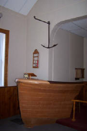
| Ship's prow pulpit |
The other main attraction in town is St. John the Evangelist Anglican Church, also known as "The Sailors'
Church," due to its nautical decor. The waterfront church is located next to the public docks, and across the street
from the lighthouse. An anchor hangs over the pulpit, and a boat's steering wheel is mounted over the altar. Net
floats are tied at the end of each pew, a gift of commercial fishermen operating out of this port. Life rings and ships'
lanterns hang on the walls.
The pulpit is the bow of a cruiser wrecked in a sudden violent storm. Four of the six people aboard
lost their lives, and the pulpit is dedicated to the hope that such a tragedy will not befall others on these waters.
The minister who serves this church, Pastor Beth, also serves a church in Gore Bay and one further away.
She conducts a 9 am service in Kagowong, an 11 am service in Gore Bay, and a 7 pm service in the other church. There
are about forty parishoners here in the summer, and fifteen to twenty in the winter, because many of the older members go
south then, a friendly woman arranging flowers in the church told us.
We ate dinner at the only "restaurant" in town -- a snack shack with picnic tables that served take-out
fare with a German flair. We thought the cabbage rolls were great.
August 9 Gore Bay
18.4 miles
The business district of Gore Bay is basically one street wide and a couple blocks long. Everything
except the Laundramat and a couple restaurants closes at 6 pm or sooner.
We visited a modest history museum in the old town jail, with a "state of the art" art gallery in an annex
just completed this year. The jail had two floors -- the lower level for men and the upper story for women, which in
days gone by were primarily used for short stays of drunk and disorderly mill workers and lumberjacks. Today the
jail is filled with a conglomeration of locally donated photos, furniture. tools, clothing and scrapbook items, sparsely curated.
We particularly enjoyed the gallery show of etchings and paintings by regional artist Michael Robinson.
The works in the show, entitled "River of Time," featured First Nations images and animals of mythic symbolism -- osprey,
turtle, raven -- presented in watery settings. We who have journeyed along many rivers for the past six
months, were drawn to the etchings and paintings, and felt they captured mystic connections we have felt, fleetingly, along
the way.
Our time in Gore Bay was watery indeed, as the 30% chance of afternoon showers and thunderstorms was fulfilled
-- beginning with a furious hailstorm dropping sharp-edged popcorn-sized pellets that bounced high when they hit. After the
hail, the weather turned to rain, with a few breaks offering hope,only to revert to rain once again.
I was "trapped" by the hail and rain in a fabric sotre/quilt shop, and inspired to buy some fancy yarn and
knitting needles to make a scarf. They didn't have a knitting book, but I had confidence that when I got back to civilization,
I could find instructions on the Internet. We shall see. . .
After checking out the recipe below, continue to Page 3 by clicking here.
|
|
|
|
|
|
|
|
|
|
|
Here's one of our favorite recipes using the tiny sweet wild blueberries we picked in the Benjamin Islands.
The recipe comes from our Ports cruising guide for Georgian Bay and the North Channel.
Georgian Bay Bear Droppings
Use equal amounts blueberries and chocolate. Melt the chocolate and carefully stir in the blueberries.
Drop by teaspoonsful on foil and cool.
|
|
|
|
