|
|
 |
We never imagined that after less than a year living on Skidaway Island it would be so hard to leave our
new friends to cruise the summer away. But, here we are, heading north, planning to be away all summer long,
and trying not to obsess over all the fun our friends back home are having without us.
We plan to meet up with friends from our Savannah biking club for a five day 2000 person bike
ride around Hopewell and Williamsburg, Virginia in the end of June.
After the bike tour, we will recover with some leisurely cruising around the Chesapeake Bay. We have
a pact to be back home by September 1. Beyond those vague parameters, our July and August itinerary is open for lots
of spontaneous adventures.
Stay tuned.
This section has three pages. If you have already read this page (through Georgetown), click
the link below to go directly to Page 2. There is another link to Page 2 at the bottom of this page.
If you have already read Page 3 (through Oriental), click the link below to go to Page 3.
Click here to go to Page 2.
Click here to go to Page 3.
|
|
Monday, June 4 Skidaway Island to Beaufort, SC
61.7 miles, 7:43 hours
We have visited Beaufort by land and water many times -- it is just a little over an hour away from home by land and
a day away by water, after all. We have toured the town by horse drawn carriage, by bicycle and on foot. We have spent
hours perusing its fine bookstores, and have eaten in most of its better restaurants. We even have rituals
we perform at every visit: (1) we eat an evening waffle cone from the ice cream parlor just three minutes' walk from
the marina and (2)we consume a latte and a sweet treat on the flybridge as we cruise away. So, we didn't expect our stop
at Beaufort to offer any surprises.
We should have known better.
Within minutes of leaving Starsong we had a Beaufort surprise as we ran into Pegge and Mike McLaughlin, previously
aboard Bahama Banks and now aboard Avalon. We met them two years ago, and then saw them again
in Marathon in February. We had them aboard for a little cocktail hour to catch up.
We will probably see them again along the way, because they, too, are destined for the Chesapeake Bay. The parallel
universe magic of cruising has begun.
The computer is being a bit tempermental, and getting this posted is turning into a major midnight oil production, as
the server or the satellite or the gremlins in space are causing whole chunks of typed copy to disappear into another dimension
of the universe.
But, I just looked back to one of my early postings on this webpage for Beaufort, and it was brimming with facts.
As I recall, I just about got writer's cramp taking notes off all the historical markers, and my pen could hardly keep pace
with our walking tour guide.. If you are interested in learing more about beautiful Beaufort -- filming location for
Forrest Gump and home of Pat Conroy, you can click on the link below.
Click here to learn more about Beaufort.
Low Country Low Humor
We saw this sign in the window of one of our favorite little breakfast spots in Beaufort (we
didn't eat there this time):
"I'd rather hunt with Dick Cheney than ride with Ted Kennedy."
Tuesday, June 5, 2007 Beaufort to Isle of Palms, SC
78.5 miles, 8:40 hours
I failed to note yesterday that Dick performed a masterful docking maneuver, parallel parking Starsong between two behemoth
boats, with a mere six inches or so to spare both front and back. He was aided somewhat by a 15-20 mph wind
pushing us against the dock.
This morning, that same wind was blowing, causing us a bit of concern about our ability to depart the dock as gracefully
as we tucked in yesterday. We got our ritual departure lattes and sweets, Dick analyzed the conditions and created an
exit strategy, then we called Mike to provide dockside spotting and back-up. Such a team -- we sprung off without kissing
either of our neighboring boats -- a good thing, since I noticed someone intently watching our maneuvers through
the slats of the blinds of the boat in front of us.
Mike and Pegge decided not to leave Beaufort, since the weather forecast called for possibly severe thunderstorms, incuding
the chance of damaging hail, this afternoon. We decided to go ahead, because, as Dick reminded me, that is the normal
marine forecast for summertime around here.
The day began sunny and clear, we saw our first daily dolphins a little after 8 am, and we enjoyed a glorious morning
of low country cruising. The clouds started building a little after 1 pm, and the approaching lightning and rumbling
thunder by 2:30 was enough to prompt us to check the marine weather forecast.
It wasn't exactly encouraging -- there was a severe thunderstorm watch until 8 pm, with hail possible tonight.
So, we battened our hatches, got our unnecessary electronics unplugged, and rushed along at 9 mph hoping to get to our
marina before the downpour began. For a while we followed close behind a sailboat, figuring their mast would be a good
lightning rod to divert the danger from us.
We dodged the storms, with just a few spatterings and smatterings of drops hitting us, while dark clouds passed over.
Then, ten minutes after we tied up at the marina dock, the skies opened, loosing a torrential downpour.
Undeterred, we waited out the rain, then off-loaded our bikes with a goal of circumnavigating the Isle of Palms
between rainstorms. Isle of Palms is about ten miles north of Charleston, via the ICW. We chose to stop here rather
than Charleston, since the tidal currents around the Charleston Marinas can get wicked, and they will be at their worst about
the time we plan to depart tomorrow. Besides, we have been to Charleston several times, and Isle of Palms never.
We circumnavigated the island in about an hour, including our stops to look at interesting stuff. Our odometers
read a little over ten miles. About half the island is the Wild Dunes Resort, a gated beach community with a couple
golf courses and a tennis club.
We learned a little island history from a brochure. The island has been a summer get-away since the late nineteenth
century. An amusement park built here in 1912 had one of the earliest Ferris wheels. The island was only accessible
by ferry and boat until1946, when the government constructed an access road and hired a developer to build low-cost housing
for World War II veterans here.
Some of that housing is still standing, we think, but there's no low-cost housing being constructed here anymore.
Outside the gates of Wild Dunes, the mix of totally tatty beach shacks and ultra-stylish megamansions side-by-side is
a zoning nightmare. Inside the gates lies a little island paradise. We did find trouble in paradise along one
stretch of beach where all that stands between several condo buildings and the lapping waves at high tide is a wall of massive
sandbags against the condo foundations. A man who has lived there for fifteen years told us that the beach erosion is cyclical,
and he has seen it like this twice before. The sand has always washed back eventually. If I lived there, I would
find it hard to keep faith alive. I would keep my flood insurance policy with me at all times -- don't leave home
without it.
|
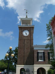
| Georgetown Rice Museum Clock Tower - built 1845 |
June 6, 2007
Isle of Palms to Georgetown, SC
53.8 miles, 5:42 hours
Within an hour of leaving the dock we saw our first daily dolphins. I heard a splash off our starboard side, and found
two small dolphins jumping in our wake and doing half flip turns to show us their pink bellies.
More plentiful than dolphins today were alligators. We saw them swimming and sunning, and they were often close
enough to look in the eye, as we cruised through narrow channels cut in the vast lowland marshes. Our most unusual alligator
sighting was one about ten feet long, floating on his back, dead in the water.
We also passed miles and miles of dikes and floodgates built in the 1700s and 1800s to control water levels in rice fields
cleared and cultivated by slave labor. Before the Civil War, this part of South Carolina supplied 80% of the country's
rice. But, after the War, when the rice plantations could no longer use slave labor, and the fields were too
swampy for mechanized cultivation, the rice business died.
Many of the rice fields live on, though, as private hunting grounds and national wildlife refuges. The floodgates are
used to control water levels for optimal duck attraction, and the wild rice is great game bird food.
|
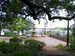
| Georgetown waterfront fountain |
We reached Georgetown in the early afternoon, so we had pelnty of time to enjoy the town. Our first stop was the
Kudzu Bakery, which we remembered from our last visit as a paradise of pastries and specialty breads. When we got there
at 3 pm, there were only two loaves of bread to choose from -- both French. The rest of the baked goods were slim
pickings, too. If you have been reading our logs for any time at all, you know things must have been in a
truly sorry state for us to walk out of there with just our big baguette.
Our next destination was the Kaminsky House, an imposing riverfront home dating to 1769, where we planned to take the
4 pm house tour. Again, we were out of luck -- three docents have strepped throat, and the only remaining well one had
done three tours in a row, was losing her voice, and had to cancel the last tour.
We did our own little walking tour, enjoying the riverfront boardwalk, which passes lots of little cafes and bars and
shops, and is lined with planters that have an eclectic mix of vegetation in them -- flowers, herbs, vegetables, little
trees -- no two are anywhere near alike, and some are downright amusing.
The boardwalk also has numerous plaques citing points of interest and providing historical perspective. Georgetown
was built on "Carolina gold" rice, named for its color as well as its economic impact. The white folks who owned the
plantations that grew it were rich beyond measure. The black folks who worked the fields were 85% of the population, but
since they were property, they didn't really count as population at the time.
Today, Georgetown Steel and International Paper are the town's economic bulwarks. Commercial fishing activity
adds local color.
A publication we picked up at our marina had a front page article claiming that the Pew Charitable Trust has "hijacked
fisheries management" using "paid-for science and a well-oiled media machine." The article accuses the Pew Chritable
Trust of disseminating misinformation disguised as science in order to influence Congressional debate about legislation to
further limit fishing -- beyond limits that already are driving many commercial fishermen to abandon the profession.
As long-time Public Radio listeners, we have often heard the name of the Pew Charitable Trust uttered as a supporter
of programming we respect. We'll have to listen more carefully to what they are supporting next time, but in the meantime, we
stopped off at a shrimp dock warehouse to buy a pound fresh off the boat to support the local fishermen (and our pursuit of
seafood happiness).
|
|
|
|
|
|
|
|
|
|
|
|
|
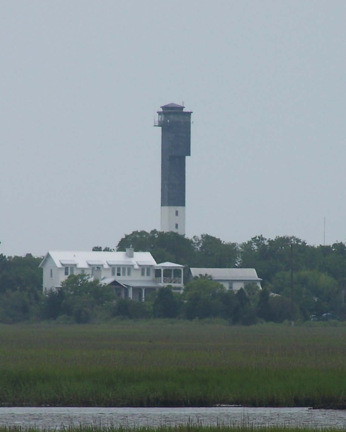
| Charaleston Light |
Charleston Light
The Charleston Light lies on the southern end of Sullivan's Island, just north of Charleston. Perhaps
the ugliest of all the east coast lights, it was built in 1962 -- not a good architectural era. Unlike earlier and more
attractive lights, it does have an elevator to whisk its keepers to the top, and it is air conditioned.
The original light at the top of the Charleston tower was 28 candlepower. It was quickly found to
be dangerous, and was replaced with a one million candlepower light, which was visible from 26 miles. The obvious question
is, if a one million candlepower light can be seen from 26 miles away, why did anyone think a 28 candlepower light was needed?
Even in 1962, navigation aids and electronics were advanced enough that ships did not need to follow a shining light visible
from halfway across the ocean to find their way to Charleston.
The Charleston Light overlooks For Moultrie, named after a Revolutionary War General who repelled a British
armada from a different fort on that site in 1776. Just a cannonball shot away is Fort Sumter on its own tiny island.
The Civil War officially began when Confederate soldiers in Fort Moultrie fired on Union troops in Fort Sumter.
Click here to continue to Page 2.
|
|
|
|
