|
|
 |
We arrived back in the United States on August 12, just three days short of spending two full months cruising glorious
Canadian waters.
We will be spending the next two to three weeks cruising the big waters of Lake Huron and Lake Michigan. We
plan to be in Chicago a little before or a little after Labor Day.
Here's what we did on Lake Huron, after we got out of its North Channel.
|
|
August 12 Drummond Island
Thanks to our chart plotter, we know almost to the minute the exact time we crossed over the border
to the United States: 1:35 p.m.
We had planned to anchor out so we would be far from light tonight, providing best viewing of the Perseid
Meteor Showers. We abandoned the plan when the day began stormy, skies didn't clear, and the weather forecast called
for strong winds from the northwest this afternoon and evening. Our anchorage was pretty open to the north, and no better
options were apparent, so we decided to just continue on to the Marina and Customs at Drummond.
There isn't much to see or do besides go through Customs around Drummond Island Yacht Haven -- no restaurants,
one small general store/grocery, a produce stand in someone's front yard, and the Drummond Island Museum.
As you can guess by now, we made a bee line for the Museum -- yet another eclectic mix of donated items
arranged idiosyncratically and curated sporadically. There were enviable fossil specimens laying on open shelves
as if they had no more value than a pile of rocks. Photos of early settlers were labeled with names, but not much context.
Farm implements, wild animal and fish mounts, someone's cub scout uniform, and other things folks cleaned out of their attics
and barns competed for our attention. We had to work to put together our vision of the local history.
The first settlers were Daniel and Betsy Seaman and their family. Daniel was an ardent Mormon, and
before they settled here, they lived in a 300-member Mormon colony on Beaver Island in Lake Michigan (more on that later,
when we visit there August 16). They left Beaver Island disillusioned, and settled on Drummond Island in 1853.
Daniel died ten years later, leaving Betsy with eleven children to support on an island with no school or church. She
sent her 11 and 6 year old boys sailing to Sault Ste. Maire, 60 miles away, for supplies. Her 6 to 8 year olds scythed
wild hay for cattle she raised. She taught her children to value culture, as well as teaching them hard work.
The Mormon religious influence on the island seems to have died with Daniel, but Betsy is revered as
a saint of resilience, industry and culture in the wilderness, and many residents proudly trace their lineage to her. Daniel
they sweep under the rug.
We had Lenny and Roxanne over for champagne to celebrate our return to the United States, and to toast the
end of a grand Canadian cruising leg together.
Afterward I used up most of our wild Canadian blueberries on a cobbler. It took over three hours to
make that cobbler, counting the blueberry picking time. It was good!
August 13 Government Island anchorage, in the Cheneaux Islands
Almost as soon as we left the Marina, we experienced cruising culture shock. We were in a major freighter
route to Lake Superior, with massive self-loading lakers in front and behind us, a Pilot boat zipping by to guide some big
boat through, and at least twenty piles of gravel several stories high beneath rows of conveyors on shore at Drummond
Dolomite Inc. Car ferries criss-crossed ahead of us between DeTour and Drummond Island. We had left the solitude
of the North Channel behind us.
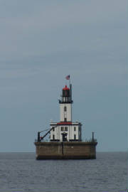
We passed two historic lighthouses on the way to Government Island.
|
| De Tour Reef Light |
The first was De Tour Reef Light. It marks the mouth of St. Mary's River, which connects Lake Huron
and Lake Superior. A light has marked this passage since 1847, but this light, completed in 1931, was the first to be
built on the reef, rather than the shore. It has recently undergone a $1 million renovation.
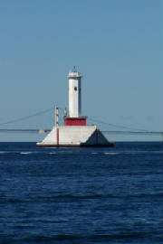
The second light, Martin Reef Light, was further away, so my picture is not as clear, but I hope you
can see that it has a square base, and is built in an Art Deco architectural style.
The base camp for building this light was Government Island. The 18-man construction crew was
housed there, and components of the light were assembled there. Construction was completed in 1927.
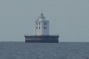
|
| Martin's Reef Light |
The Coast Guard took over operation of the lighthouse in 1939, and staffed it with four-man crews.
They opened it for the season in April, going out in a boat that pushed through the ice. When they got to the station
it would often be caked with ice, sometimes up to the third floor. They had to chip through the ice to get inside. Then
the boat would go back to the mainland, and they would be stranded at the lighthouse, able to leave only when the Coast Guard
sent them a boat.
The Bureau of Indian Affairs has owned the station and been its custodian since 2000. Why? I
couldn't find any explanation.
We anchored in a bay beside Government Island, which served as the Martin Reef Light construction base camp,
and a quarry/base camp for other lights, as well. We hiked around the island, and did see some ruins of structures left
from those past operations, but, for the most part, vegetation has reclaimed the island, and there are no ugly gashes or big
holes to be seen. Far more evident are the effects of a big windstorm which toppled many trees whose roots could not
get a deep foothold into this rocky island.
We got up at 1:30 a.m. to watch the Perseid Meteor Showers. Last night was the peak, but it was somewhat
overcast and the Drummond Yacht Haven Marina was a major light polluter, so our attempts at viewing were disappointing.
Tonight, the sky was clear, the stars were bright, and the meteors were still streaking across the sky, albeit not so frequently
as they were supposed to last night. We bundled up, lay out on our bow, saw about 10 meteors apiece, and went back to bed
satisfied.
August 14-15 Mackinaw City, Mackinac Island
The first order of business is a lesson in pronunciation. Although Mackinaw City and Mackinac
Island are spelled differently, they are both pronounced the same -- like the city is spelled.
We stayed at the Mackinaw City Marina. The last time we were in Mackinaw City was in February two years
ago, on our way to look at a boat in a shed just north of here. Back then, only one restaurant was open, there were four cars
parked on the street, which was lined with piles of plowed snow, and all the shops were closed up tight. We watched
an ice cutter escorting a cargo ship as we drove over the Mackinaw Bridge.

|
| Old Mackinac Point Light |
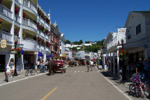
Today, we were overwhelmed by over a hundred shops dedicated to conspicuous consumption -- resort wear,
scented candles, tee shirts, at least two dozen fudge and ice cream shops, souvenir and gift shops galore -- more than any
stop yet on our Loop travels. There were flowers everywhere, rivaling Canada for public plantings and business district
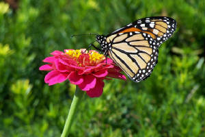
flower boxes and hanging baskets. We saw butterflies in profusion, especially Monarchs.
We rode our bicycles along a shoreline path with lots of historic signs to stop and read along the way.
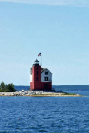
We stopped to admire the Old Mackinac Point Light, built in 1892 as a navigation aid for ferries between Mackinaw City and
St. Ignace. When the Mackinaw Bridge opened in 1957, navigators used it as a reference point, and the lighthouse became
obsolete.
Our day on Mackinac Island
We got an early morning start, and took our bicycles on the second ferry over to the island, at 8 in the
morning. The crossing took 16 minutes, traveling 30 mph.
Mackinac Island was declared America's second national park in 1875, and motorized vehicles were
banned from the island in 1898. The island is no longer a national park, but, except for motorized wheelchairs, the
ban on motorized vehicles still holds. We even saw a UPS delivery man on his cart full of boxes, pulled by a draft horse.
The streets are full of horse-drawn carriages and bicycles. People who are inexperienced in bicycle riding or in driving a
horse-drawn carriage can rent either of these vehicles to explore the island, and bicycle delivery riders with luggage and
packages piled high in handlebar baskets obstructing their view add to the excitement of streets without cars. You never know
what might be coming at you when you look both ways before crossing (not that looking both ways is a common practice around
here).
Additionally, with hundreds of horses walking the streets, the prudent bicycle rider must keep an eye on
the road itself to avoid manure, while keeping an eye on the pedestrians and vehicles to avoid collisions. Doing all
this while reading the text of a self-guided tour or attempting to follow the tour map is a multi-tasking challenge almost
equal to driving a boat through New York Harbor.
|
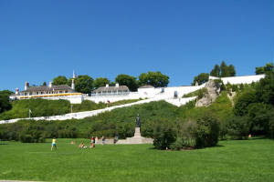
| Fort Mackinac |
Our first stop was Fort Mackinac, built high on a defensible limestone bluff by the British during the American
Revolution. American troops took it over after the Revolution, then lost it to the British in the War of 1812.
We are so confused! After all our visits to strategic military sites from the War of 1812 in Canada,
we thought the upstart Americans were the aggressors. Here at Fort Mackinac, we learned that the British and their Indian
allies were the aggressors -- landing on an isolated section of the island, marching across to the back door of the fort,
and taking the vastly outnumbered Americans -- who did not even know a war had been declared -- by surprise. The Americans
surrendered.
Eventually the Americans got the land and fort back, and it became a very cushy posting after the island
was declared a National Park, and the post commander and his soldiers were given responsibility for its care. Evidently
those duties included lots of socializing with the resort visitors, and closely monitoring the local drinking establishments.
We scanned the service records of soldiers posted there, and found that about 3/4 were disciplined, many for being drunk and/or
disorderly in town or failing to return to the fort on time after a night on the town.
We ate lunch at a table with a big yellow umbrella on the fort ramparts, overlooking the ferries, lakers
and pleasure boats passing in the harbor below.
|
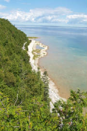
| View of the clear Huron waters from the island peak |
After lunch, we took several self-guided bike tours around the island, exploring the woods, riding past
elegant Victorian era "cottages" of generous proportions, and sneaking into the Grand Hotel without paying the $10 fee for
non-guest visitors. The hotel, opened in 1887, has the longest colonial porch in the world, and claims to be "the
world's largest summer hotel." It also has the most flamboyant color scheme of any hotel in a non-tropical destination
-- the lobby has Barbie pink and lime green furniture on a black carpet abloom with bright geraniums. After strolling
around the dining room and inspecting the $45 luncheon buffet, we completed our unauthorized tour of the hotel, returned to
our bicycles, and were on our way.
We finished our day on the island with a perimeter tour along the eight mile road that circles the island.
Sharing the road with hundreds of other bikers, we felt like we were on a bicycle superhighway, complete with traffic
jams, fender benders, and even a highway rest stop at the halfway point.
Of course we could not leave the island without a box of fudge. Tourists here are called "fudgies,"
because they are responsible for buying 10,000 pounds of Mackinac Island fudge per day. Due to our interest
in history, we purchased our fudge from Murdick's, the oldest purveyor of fudge on the island, established in 1887.
When we rode the ferry back to Mackinaw City, the captain warned people on the upper deck not to sit in
front, because they would get wet from spray. We sat below, reading the New York Times, watching the spray slap our
windows, and hoping that we never find ourselves on the Lake in our boat in weather like this.
|
|
|
|
|
|
|
|
|
|
|
Michigan has 120 lighthouses, more than any other state.
|
| Round Island light |
Two lighthouses are visible from Mackinaw Island. The oldest one is Round Island light, built in 1895.
It was home to a head keeper and two assistants until 1924, when it was automated. In 1947, a new
and improved automated light was erected just across the strait separating Round Island from Mackinac Island, and the Round
Island light was abandoned. A decade later, when Round Island became part of Hiawatha National Forest, the Park Service
gutted the lighthouse interior, and weather and vandals enhanced their efforts at destruction.
In 1974, the light was placed on the National Register of Historic Places, and its fortunes turned.
With a grant from the Advisory Council on Historic Preservation and lots of volunteer sweat equity (plus some work by crews
for the film "Somewhere in Time," which included the light in some scenes), the exterior of the lighthouse was restored.
Plans for interior renovation are underway.
|
| Mackinac Island Light |
This is the automated light that was built just off the Mackinac Island breakwater to replace the Round
Island Light. Technically, it isn't a lighthouse -- it is fully automated, with no tender's quarters. But, it
is more attractive than most automated lights. The dark spot you see near the top of the light tower is a profile
of Chief Petoskey.
|
|
|
|
