|
|
 |
|
|
|
Tuesday, July 12, 2005 Fenelon Falls to Lake Simcoe
28.7 miles/8 locks
Barbara sent us off in the morning with a beautiful bouquet
of flowers from her garden, and Norm, our pilot for the day.
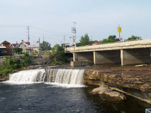
We got to the Fenelon Falls lock, just around the corner from the Hewtons' dock, with plenty of time before
its first opening of the day, which gave me time to look at the falls and nearby plaques, where I learned that Fenelon
Falls Electric Light Company was one of the first plants to supply hydroelectric power in Ontario. In 1894, a flour mill at
the falls constructed the plant, which generated 30 kilowatts of power. The mill sold the excess power to local customers.
|
| Fenelon Falls |
The current plant at the falls generates 2,600 kilowatts of power. Compared to a coal-burning plant
generating the same amount of energy, the Fenelon Falls Hydro Plant saves 17,000 tons of carbon dioxide emissions per year.
It is just one of fourteen hydro plants on the Trent-Severn. Norm told us that Ontario has a goal of getting the whole
province powered by hydroelectric plants by the year 2007. Everyone here already refers to electricity as "hydro," which
took us a while to understand.
By the time we got out of the Fenelon Falls Lock, it was clear that an extra hand made locking through a
breeze. What a treat to have Norm aboard!
Shortly after we got out of the lock, Ceilidh and Summertime called us on the radio.
When we asked where they were, they said they were approaching from starboard and almost right beside us -- and so they
were. What a treat to all be traveling together again!
Our second lock of the day, Rosedale Lock, was the last lock that we rode up. We emerged onto Balsam Lake,
the highest point on the Trent Severn Waterway. From here to Georgian Bay all our locks will take us down.
|
| Treetop view over the rim of the Kirkfield Lift Lock |
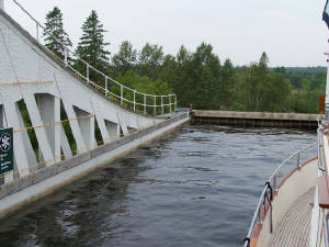
Our third lock of the day was the dreaded Kirkfield Lift Lock, approached via a very narrow limestone-lined
channel thick with cedars along its banks.
The Kirkfield Lift Lock is just 45 feet, 20 feet shorter than the Peterborough Lift Lock. The reasons I
dreaded it more were: (1)its structure is an open frame metal design rather than cement, so it has more holes to see
how far up you are and it doesn't seem as "substantial" and (2)going down, rather than up, you are facing out into the
air and sky, rather than a wall, and looking at an abyss is scarier than looking at a wall.
Fortunately, Norm took my spot at the bow, and I just held on to a stern line and averted my eyes as necessary.
It was a peaceful descent.
|
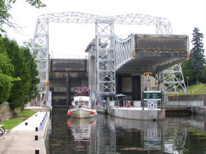
| Ceilidh emerging from the lock |
This was our hottest day yet -- a scalding 98 degrees at 3 pm. It took us nearly eight hours to travel less
than 30 miles -- slowed by long stretches of narrow canals with 6 mph speed limits, and by eight locks. We
were glad to get to the wall at the entrance to Lake Simcoe at the end of the day.
Barbara joined us there for cold drinks and snacks, then she and Norm left with our heartfelt thanks.
We went for a swim to cool off, then all got together for dinner in our air-conditioned cabin with the generator growling.
Note: Today is July 13, and we are now in Orilla, a good-sized city with our first
Verizon signal since Peterborough. I am working frantically to update the web site, but a thunderstorm which has been
hovering and giving us periodic squalls is once again throwing some heavy duty lightning, and I need to shut down.
Our recent pattern of going days without a Verizon signal is likely to continue. In fact,
it will probably get worse as we cruise Georgian Bay and the North Channel. My entries will go with the
flow.
Wednesday, July 13, 2005 Across Lake Simcoe to Orilla
18.9 miles -- 2515 for trip
We headed into Lake Simcoe at 8 a.m. Despite the many warnings about the lake's changeable nature
and dangerous storms, our two-hour crossing was on glassy waters.
We tied up at Orilla mid-morning, and soon discovered our Verizon card worked. I updated our website,
while Dick washed the boat and filled our water tanks. We explored the town a little bit, then returned to the boat
-- wandering about the city streets in humid mid-90 degree heat was not pleasant.
We shared cocktails with our cruising friends in the air-conditioned comfort of Summertime's cabin
as afternoon showers began to blow in. By the time we split for dinner, thunderstorms with squall winds were arriving.
The thunderstorms lasted for hours, but we managed to find a break in the lightning to all don our rain jackets and walk through
the storm to an ice cream stand. We wondered if we were crazy to be walking about in this weather, but we certainly
weren't as crazy as the people standing on the end of a dock fishing, holding umbrellas over their heads like little lightning
rods.
After we got our ice cream cones, Dick and I continued on in search of a virtual geocache across the park
from the ice cram stand. The site was a statue of the by now familiar figure of Samuel de Champlain. Like
the statue of Champlain we saw in Ottawa, this statue has him standing high on a pedestal overlooking the waters he explored.
The Orilla statue has additional sculptures at the base of Champlain's pedestal -- on one side two indigenous people sculpted
to look entirely heathen cower at the feet of a priest holding a cross aloft, and at the other side, similarly sculpted native
people are crouched below a noble explorer. The plaque on the statue was placed in 1915, commemorating the 300th anniversary
of the "arrival of the white race" to these shores.
Not far from the statue of Samuel de Champlain we found a simpler commemorative plaque remembering three
treaties with the Hurons which resulted in the indigenous people turning over huge tracts of land in this region to Great
Britain. The British then gave the land to Loyalists and militiamen, and others they wanted to reward with land grants.
|
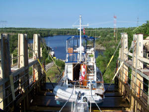
| The Big Chute Carriage |
7/14-15 Port of Orilla to Big Chute and Beyond
Our passage from Orilla to Big Chute took us through evergreen-lined lakes and narrow channel cuts alternating
with the Severn River. The water was clear, and many vacation cottages with docks and boathouses lined the granite shore.
Flower boxes and gardens provided bright splashes of color in abundance.
We arrived at Big Chute, site of the Big Chute Marine Railway at 2 p.m. We tied up to the railway
dock, and watched other boats get loaded onto the railway car, make the slow ascent out of the water, across the road, and
then down the big chute to the water below.
Our plan was to spend the afternoon at Big Chute, then get our boats on the first run the next morning.
|
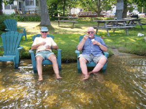
| Dick and Lenny cool off |
It was yet another warm day, so we found ways to cool ourselves. Our best antidote was to sit on plastic
chairs in the water, under a shady tree, cooling our feet in the water while cooling our tongues with ice cream.
The next morning, Gayl spent an hour birding while enjoying the peachy clouds and warm light of the waning
sunrise, before we moved the boat to the blue line at 7 a.m. (The blue line is literally a blue line painted on the
side of a wall where you dock your boat while waiting for a lock passage. Only boats waiting to go through can park
on the blue line.)
|
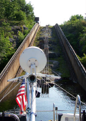
| View from the top of Big Chute |
The railway could not carry all three of our boats at once, so the lockmaster called Summertime
to go in first, and Starsong to follow.
Driving the boat onto the railway car is like driving onto a big boat trailer. We pulled in over the
submerged car, and the lock hands asked us a bunch of questions about our keel and the location of our running gear as
they adjusted straps that passed under the boat to cradle us and hold us in place for our journey over land. The
back third of our boat stuck out behind the railway car platform, which made me feel like we might tip off the back, even
though rationally I knew that the straps were in the same spot they put them when our boat is hauled out of the water for
dry work. Of course, I never ride in the boat when it is being pulled out on a travel lift (and I always worry about
a strap breaking and dropping the boat when it is pulled out, too).
As the car moved over the railway tracks we could feel each spot where the rails joined as a little jolt.
|
| Looking back up the Chute from the bottom |
The railway took us 748 feet, up a low bank, across a road with traffic stopped by railroad crossing gates,
and then down the steep and rocky Big Chute. That downhill ride wa the exciting part. At a maximum speed of 200
feet per minute, it may not be as fast as a roller coaster, but the feeling of heart rising to throat was certainly there
(at least for me) as we stood on the flybridge and looked at the tracks below us running down to the water below. The
whole trip took just ten minutes, not counting the time it took to load and unload. At the end of the ride, we
were in a body of water 57 feet lower than the one we started in.
At the end, we tied up, then ran up the steps of Big Chute to get pictures of Ceilidh riding the
railway.
After the Big Chute Railway, we had just one more lock to complete our Trent Severn Waterway trip.
We passed through the Port Severn Lock, and our adventures in Georgian Bay began.
|
|
|
|
|
|
|
|
|
|
|
|
|
|
|
