|
|
 |
|
|
|
Monday, June 13, 2005 Burlington, VT to Plattsburgh, NY
20.3 miles
As expected, we arose to yet another foggy morning on Lake Champlain. We dinghyed into town for coffee
and pastries with the New York Times. Then we headed back to the boat to make leisurely preparations for a short
cruise over to Valcour Island.
As Dick was starting up the chart plotter, he realized that the chart with Valcour Island on it was not
registering correctly on the computer. I was not comfortable leaving with the threat of thunderstorms and an inoperable chart
plotter. We delayed our departure while Dick called the software manufacturer to determine if he could fix it. The tech
support person talked him through the chart repair, and we were good to go.
When all was said and done, we didn't leave until after 2 pm, which made us (me) a little nervous,
given the tendency of thunderstorms to build in the afternoon. On the way to Valcour Island, we heard a Coast Guard
Security Call on the radio, forwarding a Burlington National Weather Service Severe Thunderstorm Advisory for tonight,
with the possibility of two to three foot waves on the lake.
As we cruised the shore of Valcour Island, checking its coves for potential anchorage spots, no place seemed
to provide a safe enough haven for me, given the impending weather. I told Dick, "I would rather worry about hitting
docks than rocks."
He obligingly took me to the Plattsburgh Marina, where we tied up to a well-sheltered dock, and went
ashore for a walk and dinner at a Mexican restaurant with fabulous Margaritas recommended by the locals on the sailboat
next to our overnight slip.
On the way to the restaurant, we hunted for a geocache that introduced us to Plattsburgh's most significant
historic event. On September 11, 1814, the battle that ended the War of 1812 was fought in Plattsburgh.
England sent 15,000 troops and a fleet of Royal Navy ships from Canada to attack the US from the north.
The US troops were vastly outnumbered, but had local knowledge. Lt. Thomas Macdonough lined up the US fleet in Cumberland
Bay in a way that prevented the British Navy from taking advantage of their superior guns. The British were unfamiliar with
the local winds, their commander was killed early in the battle, and they withdrew after two and a half hours, with their
fleet smashed and sinking.
Meanwhile, Britain's land forces had gotten lost in the dense woods, so they were delayed in making their
attack. By the time they got to town, the outcome of the Naval battle was clear, and they withdrew.
The Battle of Plattsburgh effectively ended the war. If the British had been victorious, Northern
New York, much of Vermont, New Hampshire and all of Maine would have gone to Britain.
Today, a tall obelisk with a flying eagle atop it looks over Cumberland Bay. It commemorates
the Battle of Plattsburgh and honors Thomas Macdonough. The names of his four ships are carved on its four sides --
Eagle, Ticonderoga, Saratoga, and Preble.
Tuesday, June 14, 2005 Plattsburgh to Rouses Point, NY
26.9 miles
Dodging Ferries in the Fog
We began the day with a walk around a decommissioned Air Force Base just up the road from the Marina.
The large Victorian-style buildings that served as officers' housing are now 3500-4000 square foot town homes, and other base
housing is being converted to condominiums. The base field house is a recreation center, a fitness path runs along the
lake shore, and the old base marina has waterfront picnic facilities and a tour boat dock. We chatted with some residents
sitting out on their porch having morning coffee with neighbors.
We have read a lot lately about the many military base closings under consideration, and how hard state
and local representatives are fighting to keep them open. This base seems like a model for productive post-military
use of the facility -- enhancing the community and pumping tax revenues into the local economy.
As we were walking back to the boat, it began to rain. As we were preparing to leave, it began to
rain harder. We waited for it to let up, and it didn't. We waited for the fog to get washed away by the rain,
and it didn't.
Finally, at a little after noon, we decided that the day was not going to get better, and the longer we
waited to leave, the more we increased our chances of hitting afternoon thunderstorms.
|
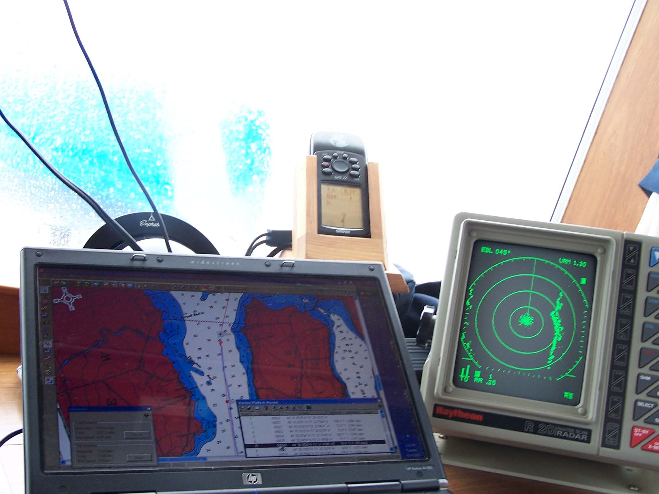
| Electronic fog survival kit |
We drove from the lower helm station inside the cabin, where we have radar and windshield wipers.
It wasn't long before the radar saved us.
We found ourselves in a particularly thick fog bank just as we were getting to the area on our chart marked
as a ferry crossing. Visibility was less than a quarter mile. Dick watched the radar screen for green dots, and
I strained my eyes to look out into the fog. Dick saw a dot on the screen, took what he hoped was evasive action, and
I watched in the direction of the dot -- a ferry came looming out of the fog. As I was trying to figure out what direction
it was going, Dick saw another dot, and we had to do a quick turn and weave between the ferries passing in opposing directions.
Throughout the whole maneuver, Dick was operating only on instruments -- the GPS and compass providing our
sense of direction, the chart plotter providing a picture of where we were on the chart, and the radar giving rough land contours
and the dots indicating other boats or navigation marks.
Ironically, once we got past the ferry crossing, we hit a clear space, and could look back a couple miles
to clearly see the ferries docking.
Our trip took a little over three hours. It was pretty miserable all the way.
When we were within 15 minutes of the marina at Rouses Point, as I was out in the wind and rain putting
out our fenders and lines in preparation for docking, I heard a siren, looked up and saw a boat with a flashing blue light
approaching.
It turned out to be Homeland Security. They tied up to our boat and put a foot aboard to ask us questions
about our intentions. After we bobbed around a while, one of the crew came out of the cabin and told our interrogator
that we were okay. Evidently he had been plugging us in to some computer that didn't have any data about how critical
we have been of the current administration.
They untied their boat, revved up their super-powered engines and zoomed off, rocking us in the biggest
wake we have encountered since New Jersey. Dick tried to call them on the radio, but they did not answer. Maybe
they knew our political views, after all.
We were tied up at the marina at Rouses Point a little before 4 pm. Shortly after 4, the rain stopped.
We hopped off the boat for an exploratory walk. Rouses Point is less than a mile from the Quebec border.
Canadian and American flags fly from the lightpoles along the main street of town, and many businesses have signs in both
English and French. Although there are many vacant storefronts, the town is making a mighty effort to remain vital.
Flower boxes and hanging flower pots are everywhere. One business even had a long sparsely planted flower box out front
with a sign saying, "Feel free to contribute flowers. Just plant them here."
|
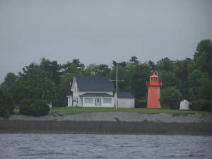
| Isle La Motte Light |
We did manage to see one interesting lighthouse today. It was on Isle La Motte in Vermont.
This lighthouse was built of cast iron and lit in 1881. The first keeper was Wilbur Hill, who kept
the previous light on the island before he kept this one. He also kept a 100 acre farm nearby. He retired in 1919
after 48 years of service, and died six weeks later.
The light was deactivated in 1933 when an ugly black steel skeleton light (think of a little radio
tower) was constructed. The old light tower and keeper's house were sold to a dentist, who later sold it to the Clark
family, who own it now. They worked with the Coast Guard to get the historic light reactivated. The light was relit
in 2002 at a big party with 300 people attending. A group of schoolchildren lit it, including the great granddaughter
of Wilbur Hill. It is once again an active aid to navigation.
|
|
|
|
|
|
|
|
|
|
|
A few Vermont facts in passing:
Vermont is the first state we have visited which has an official state flavor. Vermont's state flavor
is maple.
Its state tree is the sugar maple.
The state bird is the Hermit Thrush.
The state fruit is the apple, and the state beverage is milk.
The state song was composed as part of a contest, and chosen by popular vote of the citizens of Vermont
back in the 1990s. Here are the words:
These green hills and silver waters
Are my home -- they belong to me
And to all her sons and daughters
May they be strong and forever free.
Let us live to protect her beauty
And look with pride on the golden dome.
They say home is where the heart is --
These green mountains are my home.
These green mountains are my home.
words and music by Diane Martin
|
|
|
|
