|
|
 |
|
|
|
Saturday, May 8 Exploring Norfolk
The rain was gone Saturday, but strong winds continued, so we stayed put, as did just about all the other
boats at the marina.
Norfolk lies right across the Elizabeth River from Portsmouth. A ferry has connected Portsmouth and
Norfolk since 1636. The first ferry was rowed across the river and carried only foot traffic, but by 1720 a ferry carrying
carriages crossed the river. A century later, the oarsmen were replaced with blind horses on treadmills. In 1832,
steam power replaced the horses, and now the ferry is diesel-powered, but has a fake paddlewheel on back to hearken back to
ferries past.
The trip across the river takes ten minutes and costs $1 (half price for Seniors). Norfolk's waterfront
is much busier and more commercial than Portsmouth's. A "boutique mall" with tourist shops, a food court and chain restaurants
sprawls across the wharf where the ferry lands. A cruise ship docking area is next door.
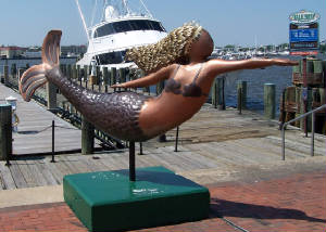
There are lots of modern high rise offices and a large generic shopping mall interspersed with little parks
downtown. Recently the city decided to adopt the mermaid as its mascot, and had a mermaid statue decorating project
like Cincinnati's pigs and Rochester's horses. The mermaids are all over town.
We walked the Cannonball Trail through the historic district of Norfolk, ate lunch in one of the historic
buildings, and took a tour of the Victorian James W. Hunter House, which is an odd combination of authentic furnishings and
family artifacts, and flamboyant Designer Showcase wall and window treatments which are creative interpretations of how the
home "could have been" decorated.
The city has survived lots of catastophies. The Cannonball Trail gets its name from a cannonball that
has been embedded in the wall of St. Paul's Episcopal Church since 1776. The church is the only Norfolk structure that
survived the Patriots' efforts to burn the town in 1776 to keep it from British occupation. In 1821, the Great Gale
destroyed much of the rebuilt Norfolk. Then, in 1855, the steamer Ben Franklin brought
a yellow fever epidemic to town that wiped out a third of Norfolk's population.
In the past 100 years, the Edgar Cayce Hospital offered clairvoyant diagnostic services here from 1928 to
1931, and the first baby conceived by in-vitro fertilization was born here in the early 80s. There wasn't a public high
school for black students here until 1938. Then, when the Federal Government mandated school integration, Norfolk's
white public schools closed down in 1958-59 to avoid it. An estimated 9,950 white children remained out of school until
the stand-off was resolved with "peaceful integration."
That's Norfolk in a nutshell.
Sunday, May 9 Portsmouth to Old Point Comfort
18.8 miles
"Shiver me timbers, blow me down"
We were off the dock in big wind with high hopes for a calming as the morning wore on. Our hopes were
dashed.
As we got about five miles into the bay and were being tossed about aby four to five foot waves sending
spray over our bow and up to the flybridge, it occurred to us that:
1. We weren't having fun anymore.
2. Sixty more miles of this turbulence to get to our destination of Onanacock would be intolerable.
3. Our "duck-in" fall-back destination was two hours away--also intolerable.
While Dick wastrying to reason the implications of these observations, I quickly came to a conclusion, and
suggested we turn back. Dick complimented me on my quick thinking, and turned us around.
Did you know the word nausea comes from the Greek word naus, meaning ship? I hasten to add
that neither one of us felt seasick -- just strained and uncomfortable trying to keep our balance, keep the boat on course,
and keep from being thrown against something hard on the flybridge.
Dick analyzed the chart to find the closest refuge, and took us around Old Point comfort. We think
we know how that place got its name. It sure gave us comfort to round the point, where the waves didn't have so much
room to build, and the land broke the wind a little bit.
We dropped anchor in Mill Creek, bordered on one side by I-64 causeways and on the other by Fort Monroe.
Originally, we were just going to anchor there while we decided what to do. Tne we decided to just stay right there.
Fort Monroe is the largest stone fortification ever built in the US. It was begun in 1819, and completed fifteen
years later, while Robert E. Lee was a Lt. of Engineers there. During the Civil War, it was known to slaves as the "Freedom
Fort" when General Benjamin Butler decided in 1861 to accept slaves at the fort's gates as "contraband of war." At the
end of the war, Confederate President Jefferson Davis was imprisoned there, accused of plotting to kill President Lincoln.
He was released two years later.
Today, the fort is the centerpiece of the Fort Monroe Army Training and Doctrine Command -- "Where Tomorrow's
Victories Begin."
We know all this because, despite our cruising guide's cautions about post 9/11 security restrictions around
this strategic planning and training facility, dick called the on-base marina, and got permission to bring our dinghy in to
visit the post's maritime museum. Once on base, we not only checked out themuseum, but did a walking tour of the base.
no one seemed to notice us. it was Sunday, and no one was in uniform.
You could mistake the base for a beautiful small waterfront town with lots of gracious historic homes, except
the front steps of each home are stenciled with the rank and name of the enlisted person living there.
While exploring the base, we found several other locations of note:
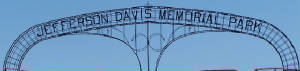
The Jefferson Davis Memorial Park, dedicated May 5,1956 by the United daughters of the confederacy is a
testament to the lasting power of sentiments about the good old days of the Confederacy in this area.
The Zero Mile Post for the Chesapeake and Ohio Railway is here. Beginning in 1889, this was the point
from which all distances on the main line were measured for the 664.9 miles it ran to Cincinnati.
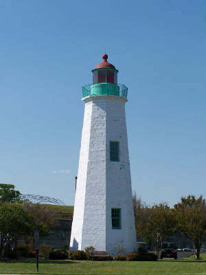
The Old Point Comfort light is the oldest standing structure at Fort Monroe, and it remains an active navigation
aid. During our voyage today we took some crooked and blurry pictures of it as we rocked and rolled. This picture
we got on stable land.
|
|
|
|
|
|
|
|
|
|
|
|
|
|
|
