Friday, April 22, 2005
Barefoot Landing, SC to Southport, NC
44.6 miles
A pontoon bridge that only opens on the hour lies fifteen miles north of Barefoot Landing. Consequently
we had to strategically time our departure to get to the bridge near the hour. Strategic timing is difficult when one is
not familiar with the strength of local currents and the number of "No Wake" zones along the way, so we left at 7:40,
planning to catch the 10 am opening, figuring we could always slow down if we appeared to be getting there early.
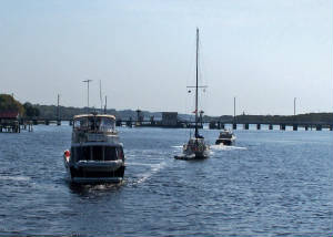
|
| Wating for the bridge to open |
We had plenty of help from the currents, covering 9.7 miles our first hour, so we poked along the second
hour. When we got within sight of the bridge, ten sailboats were already lined up waiting to go through. An impatient
power boat who had sped past ten minutes earlier, rocking us in his wake, was at the head of the line, pacing.
We followed fellow Loopers in MT Pockets to a spot near the bridge. Skipping the line in
front of the sailboats was permissible--in fact, preferable to passing them in the narrow channel following the bridge.
|
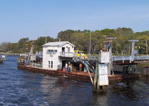
| Passing through the opened bridge |
Sunset Beach Pontoon Bridge is the last remaining pontoon bridge in North Carolina. The bridge floats
on a barge, and is opened by a wire that swings it to the side, like an opening door. We kind of hoped that the speedy
boater who rocked us and all the other boats in line would jump the gun and hit the wire, but he waited for the bridge tender's
signal that the wire was down and it was clear to pass.
We counted 14 boats in the parade passing through going north, none waiting to go south.
Our adventures weren't over yet. Our next challenge was a stretch of the ICW infamous for narrow channels,
strong currents and shoaling. Passing Shallotte Inlet, our speed dropped in seconds from 11.5 mph to 7.4, as the current switched
in an area that resembled a pot of boiling water.
We hit the dreaded shallow and narrow Lockwood's Folly at low tide. We made it through safely, but
noticed on our depth finder that the screen was fuzzy--the way it looks when we are near a barge stirring up mud. We
thought it must be picking up lots of sand suspended in the strong current which was slowing us by 2 mph. Later, we
heard a couple sailboats who had gone aground there calling for assistance.
We were in our berth and ready to explore Southport by 2 pm. Still, it felt like a long day.
Saturday, April 23, 2005 Southport, NC
In the early 1700s, the area around what is now Southport was a haven for pirates. In the mid-1700s
a fort was built at the mouth of the Cape Fear River, and a community of river pilots, fishermen and military began.
In 1792 the General Assembly of South Carolina commissioned five men to create a town here. Originally named Smithville,
after one of the commissioners, the town became a popular summer resort because of its pleasant sea breezes.
In the 1880s, businesses from the North had a vision of making the town into a major port. As
a promotional effort, they changed the town's name to Southport. The vision never became reality, but the name stuck.
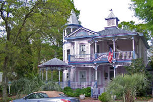
|
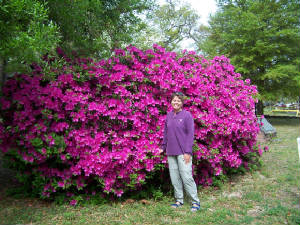
| Our favorite house--a real painted lady |
Today, the town is still a community with river pilots and fishermen, where tourists flock for the
refreshing breezes. Large freighters pass by on their way up the river or out to the ocean. If it weren't
for the azeleas, Southport could be mistaken for a picturesque New England fishing village.
One of the most thrilling aspects of the town for us was that it is right across the river from Battery
Island, one of the most important nesting sites in the country for white ibises. Thousands of pairs arrive at the island
in the first few weeks of April. In the morning, we saw clouds of ibises leaving the island, and in the afternoon we
saw them flying back to the island after feeding in marshes around Southport. The sight was awe-inspiring, and the numbers
mind-boggling.
We spent the morning doing an historic walking tour using a map from the Visitor Information Center, and
doing a multi-stage geocache that took us to historic locations about town. We walked up and down the main street of
town, checking out interesting shops. Of course, we couldn't resist the local bakery, where a seven-year-old boy practiced
his math by cashing us out, while his mother provided cash register coaching as needed.
We had hoped to visit the local Maritime Museum, but it was closed for repairs.
|
| Azeleas are at their peak here. |
As we were walking back to the boat with bags of puchases in hand, a man in a pick-up truck stopped and
asked if he could give us a ride. We thanked him, but declined the ride, telling him we were on a boat and needed the
exercise. He told us he came from Michigan 18 years ago and wouldn't live anywhere else. He said it's
the kind of place where you can walk anywhere at any time of day or night, and people are friendly to strangers. He was a
living example of that point.
Tomorrow we have two low bridges with opening schedules that will hold us up, and leave us circling in bad
currents. With the mast down, we can squeeze under them. So, when we got back to the boat, Dick put together his
special rig for taking down the mast single-handed, and made a custom mast crutch to hold the mast and boom while we are under
way. Then, with minimal assistance from me, he brought the mast down and secured everything
with a dozen bungee cords and a bunch of lines. It wasn't pretty, but it seemed secure.
We had dinner at a very casual waterfront restaurant called The Provision Company. We ordered a pound
of shrimp at the counter by the door, picked up our drinks from a cooler, and sat at a table out on a patio next to the dock,
with a windscreen flapping a bit in the brisk breeze. Our shrimp was delivered in a paper tray with plastic cups of
cocktail sauce on the side. We peeled them, messy with Bay Seasoning, and had a most rustic and
most delicious meal, topped off by ice cream cones from a place across the street also owned by the Provision Company.
Sunday, April 24, 2005 Southport, NC to Harbour Village
Marina (across the ICW from Topsail Island)
42.3 miles
What is in a name?
This is the question we pondered as we pushed off the dock and into the Cape Fear River. Dick
asked, "If it was called the Apple Blossom River, would we have this much trepidation about it?"
If the Apple Blossom River had a nasty current of four mph, a history of shoals forming overnight, Pilots
on duty 24/7 to guide ocean-going vessels through hazards, and two Towboat US vessels sitting on the docks waiting for business,
I think the answer is obvious.
We did phone up the Cape Fear Towboat US office to get local knowledge and advice in planning our journey
up the river. You may be wondering if this is like asking a tobacco company for advice on how to quit smoking.
Not really. Towboat US seems to have plenty of business, so they are happy to give advice as good public relations.
And, who better to ask for advice than towboat captains who know the rogue currents and boat-grabbing shoals intimately
from personal experience? (This question will come back to haunt us tomorrow.)
Based on the advice of the Towboat US captain, we left at 6:50, to catch the favorable current from the
incoming tide. We sped along at 12.7 mph, with 3.5 mph in current assistance, which is very strong,
as currents go. We kept the favorable current all the way up the river and had no untoward incidents.
|
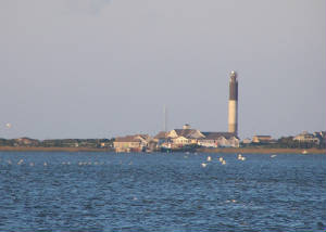
| Oak Island Light |
Before we leave the topic of Cape Fear, we have to comment on the lighthouses. Two are visible from
Southport's waterfront. They couldn't be more different.
One, on Bald Head Island, is the first lighthouse in North Carolina, built in 1795, a classic. The
other, on Oak Island, is the newest in North Carolina, second newest in the country, built in 1958. It gets our nomination
for ugliest lighthouse we have seen to date. Constructed like a silo with three different colors of concrete, it doesn't
need painting. We are attracted to old lighthouses by their marriage of beauty and utility. The Oak Island light is
utility all the way, with the second brightest light in the US, visible 24 nautical miles out to sea. Although the structure
is ugly, we imagine if you were rolling around out at sea, looking forward to safe harbor, the sight of that light would
be beautiful indeed.
Yesterday, Dick lowered our mast to get under two poorly timed bridges today without waiting, and the strategy
worked -- although on the first bridge we only had one foot to spare in the middle of the bridge, meaning we would scrape
if we were off center. Dick did a masterful job of aiming us through.
We passed through lots of NO WAKE zones in front of lots of beautiful homes, and were still on the dock
at Harbour Village before noon.
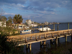
|
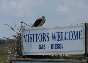
| The Osprey is a welcome visitor to Harbour Village |
Harbour Village is a lovely development of new homes around a marina and golf course. The transient
boat slips are on the opposite side of the large boat basin from the marina office and facilities. So, the Marina provides
a courtesy golf cart for transient boaters to use to get around.
After we got situated, we hopped in the golf cart to get registered at the Marina Office. As soon
as we got inside, the clouds, which had been building all morning, let loose with a squall of rain and hail. By the
time we finished registering and touring the first-rate facilites, the rain was about over. We dried the cart seats
and went back to the boat.
Too bad it rained on and off all afternoon, and threatened to cook up another big squall. There were
marshes by the harbor entrance we would have liked to explore by kayak.
|
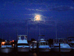
| Moonrise over Harbour Village Marina |
Click here to cruise north with us to explore Beaufort, NC.
|
